Bing daily wallpapers
page 7 / 20
| 2026‑06‑07 ‑ | United States |
|---|
| en | • | Atlanta Botanical Garden, Atlanta, Georgia |
| (© Marcus E Jones/Shutterstock) |
National Garden Week
Since opening its doors in 1976, the Atlanta Botanical Garden has proven that beauty can be organized. Beds are planned, labels are placed, and every plant has a job. 'To have a garden is not as easy as it seems; it is just as difficult as governing a kingdom.' Nobel Prize-winning German author Hermann Hesse had a point.
Established in 1986 with a presidential proclamation, National Garden Week, held the first full week of June, leans into that idea and asks people to dig in. The group behind it, National Garden Clubs, suggests keeping it practical: host a workshop at a library or public garden, plan a garden tour, or beautify a manageable area with a group. Try something small, learn as you go, and let the plants do the talking. Gardens are a luxury, and they ask for royal attention. Treat yours like a kingdom, and it will pay you back.


| 2026‑06‑06 ‑ | International / Brazil / Canada ‑ English / Canada ‑ French / China / India / Italy / Japan / Spain / United Kingdom / United States |
|---|
| en | • | Natchez Trace Parkway, Tupelo, Mississippi, United States |
| • | Natchez Trace Parkway, Tupelo, Mississippi, USA | |
| es | • | Natchez Trace Parkway, Tupelo, Misisipi, EE. UU. |
| fr | • | Natchez Trace Parkway, Tupelo, Mississippi, États-Unis |
| it | • | Natchez Trace Parkway, Tupelo, Mississippi, USA |
| ja | • | ナチェズ・トレース・パークウェイのトレイル, 米国 ミシシッピ州 |
| pt | • | Natchez Trace Parkway, Tupelo, Mississippi, EUA |
| zh | • | 纳奇兹小径公园大道, 图珀洛, 密西西比州, 美国 |
| (© The best photo is earned/Getty Images Plus) |
Natchez Trace Parkway, Tupelo, Mississippi, United States
Near Tupelo, Mississippi, the Natchez Trace Parkway follows one of North America's oldest travel corridors. Long before paved roads and motorways, Native American communities used this route for trade, hunting and communication across the Southeast. Curious how deeply history can shape a landscape? Some preserved sections of the original trail still sit noticeably below ground level, worn down by centuries of footsteps, horses and wagon wheels. Later, European and American traders, soldiers and explorers relied on the path during the late 18th and early 19th centuries.
Today, the parkway stretches 715 kilometres through Mississippi, Alabama and Tennessee, linking forests, farmland, wetlands and historic landmarks. Unlike many highways, commercial traffic is restricted, helping preserve its quieter atmosphere. Travellers can stop at ancient burial mounds, pioneer inns and scenic overlooks while spotting deer, wild turkeys and songbirds along the route. Ever wondered what travelling across the American frontier once felt like? The Natchez Trace still offers glimpses of that slower world today.


| 2026‑06‑06 ‑ | Germany |
|---|
| de | • | Plönlein mit Siebersturm und Kobolzeller Tor, Rothenburg ob der Tauber, Bayern |
| (© Harald Nachtmann/Getty Images) |
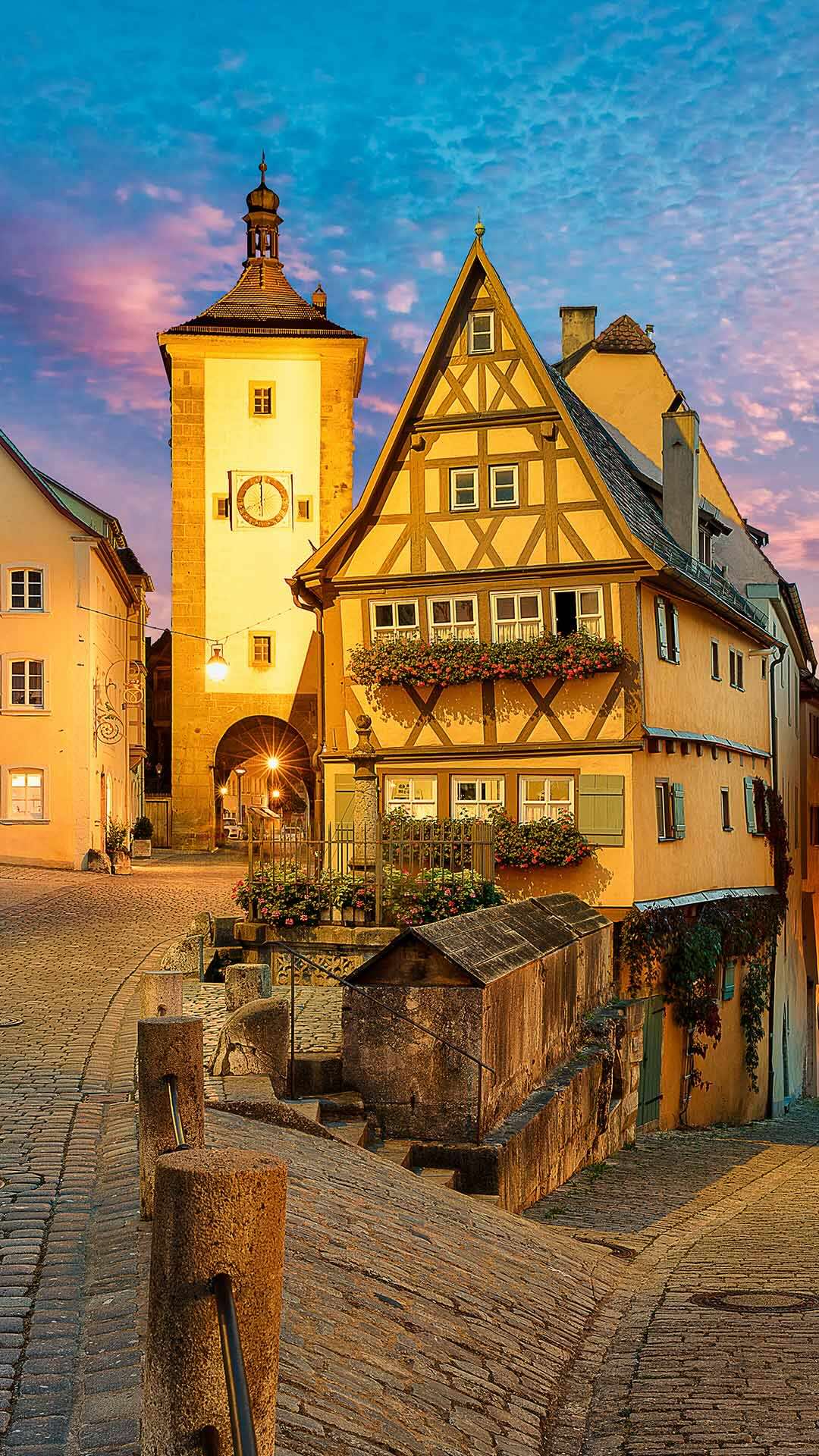
Plönlein, Rothenburg ob der Tauber, Bavaria
The Plönlein is one of the most famous photo motifs in Germany. But what is really behind it? Located in the heart of the historic old town of Rothenburg ob der Tauber in Bavaria, it is much more than the iconic half-timbered house that many know from postcards. The name comes from the Franconian "Plänlein" and refers to a small square, usually by a fountain.
This is exactly where the typical scenery of the Plönlein can be seen: a small square with a fountain, a leaning half-timbered house and two towers of the old city wall. On the left, the Siebersturm leads into the historic hospital district, on the right the Kobolzeller Tor opens up a view of the Tauber Valley. This unusual composition of architecture and perspective gives the place an almost fairytale-like effect.
For decades, the Plönlein has served as a visual template for illustrations, films and even video games. In this context, it is often cited as a source of inspiration for the fairytale backdrops of the early animated film Pinocchio from the 1940s. Anyone who visits the place quickly realizes that it is not a single building that makes it famous, but the harmonious interplay of many elements, embedded in the grown urban structure.


| 2026‑06‑05 ‑ | International / Brazil / Canada ‑ English / Canada ‑ French / China / France / Germany / India / Italy / Japan / United Kingdom / United States |
|---|
| de | • | Blick vom Skierffe über das Flussdelta des Rapadalen, Nationalpark Sarek, Laponia, Lappland, Schweden |
| en | • | View from Skierffe Mountain over the Rapadalen river delta, Sarek National Park, Laponia, Lapland, Sweden |
| fr | • | Vue sur Skierffe et la vallée de Rapa, Parc national de Sarek, Laponie, Suède |
| it | • | Delta del fiume Rapadalen, parco nazionale di Sarek, Lapponia, Svezia |
| ja | • | サーレク国立公園, スウェーデン |
| pt | • | Vista da montanha Skierffe sobre o delta do rio Rápadalen, Parque Nacional de Sarek, Lapônia, Suécia |
| zh | • | 从斯基尔夫山俯瞰拉帕达伦河三角洲, 萨雷克国家公园, 拉波尼亚, 瑞典拉普兰 |
| (© Robert Haasmann/Getty Images) |
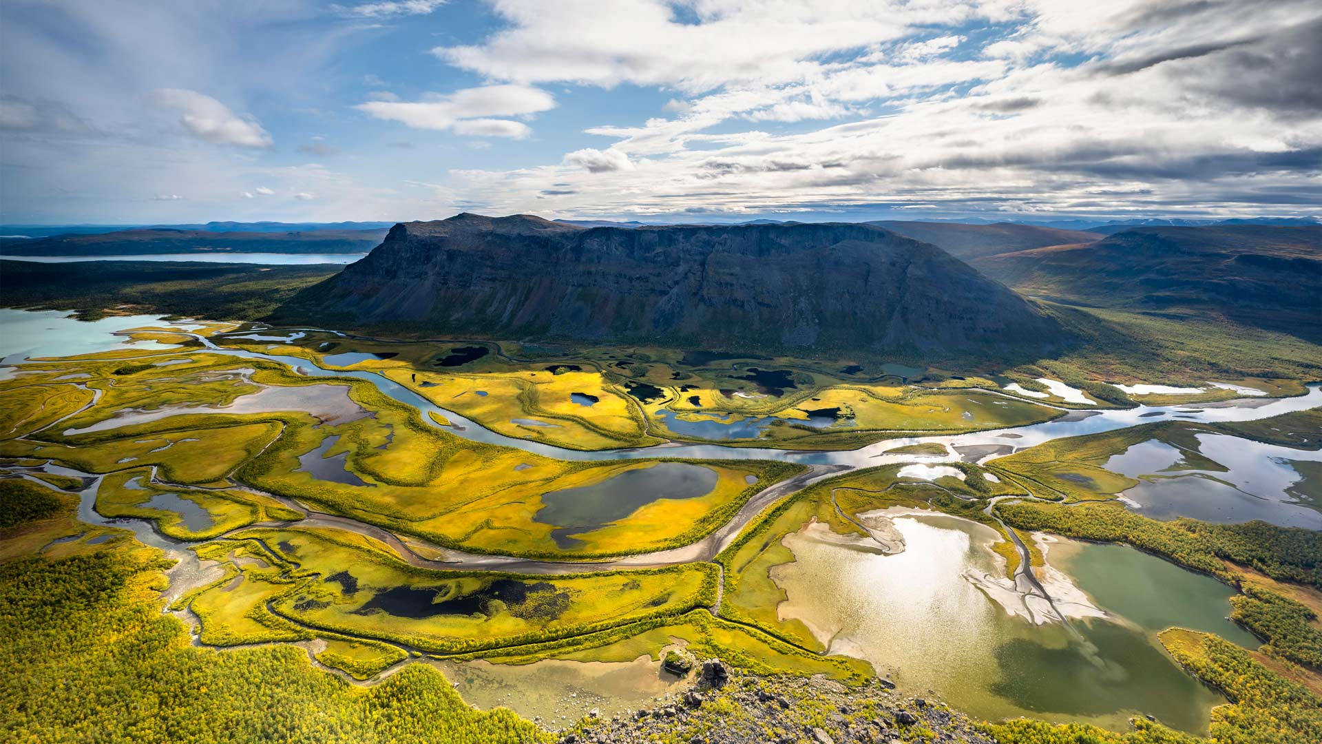
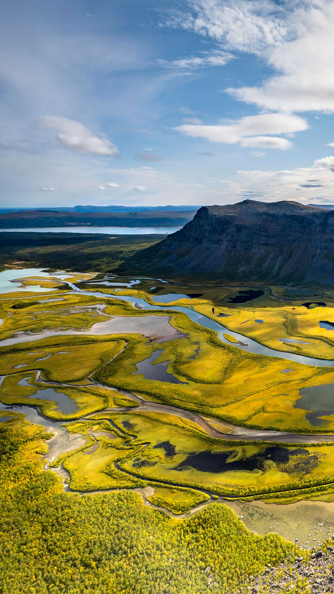
Sarek National Park, Laponia, Lapland, Sweden
If nature had a 'do not disturb' sign, it would hang over Sarek National Park, often called 'the last European wilderness.' This remote corner of Swedish Lapland reminds us what the planet looks like when humans take a step back—and let the wild take the lead.
Established in 1909, Sarek is one of the continent's oldest national parks and remains untouched by modern infrastructure. There are no marked trails, no cosy cafés and definitely no shortcuts. Instead, it offers over 200 peaks, nearly 100 glaciers and valleys shaped by ice and time. It is part of the Laponian Area, a UNESCO World Heritage Site and home to the Indigenous Sámi people, whose reindeer herding traditions still thrive across these lands.
Wildlife here plays it cool—moose, lynx and wolverines keep things low-key. Even the rivers refuse to stay still, carving their own paths through the landscape. Sarek makes a strong case for inaction. Sometimes, protecting the planet means resisting the urge to tame it.

| 2026‑06‑05 ‑ | Spain |
|---|
| es | • | Molinos de Consuegra al amanecer, Castilla-La Mancha |
| (© Paulo Costa/Getty Images) |
Mills of Consuegra at dawn, Castilla-La Mancha
In the plain of La Mancha, the windmills of Consuegra stand as a powerful symbol of the landscape and history of Castilla-La Mancha. Located on the Calderico hill, they dominate the horizon with their white blades that evoke scenes from the rural and literary past. Many of these mills have been restored and retain their original machinery, which allows us to understand their traditional function in milling grain.
In addition to its historical value, the complex is part of an outstanding cultural and tourist attraction. The nearby medieval fortress accompanies the silhouette of the mills and reinforces the heritage character of the place. Throughout the year, activities and visits are held to learn about how it works and its importance in local life. This environment offers a representative image of La Mancha's identity, where tradition, landscape and memory are harmoniously integrated, attracting visitors from all over the world in search of this unique picture.


| 2026‑06‑04 ‑ | International / Brazil / Canada ‑ English / Canada ‑ French / China / France / Germany / India / Japan / Spain / United Kingdom / United States |
|---|
| de | • | Schmuckreiher bei der Gefiederpflege, Zentralflorida, USA |
| en | • | Snowy egret preening, central Florida, United States |
| • | Snowy egret preening, central Florida, USA | |
| es | • | Garceta nívea acicalándose, Florida central, EE. UU. |
| fr | • | Aigrette neigeuse, Floride centrale, États-Unis |
| ja | • | ユキコサギ, 米国 フロリダ州 |
| pt | • | Garça-branca-pequena se arrumando, Flórida, EUA |
| zh | • | 梳理羽毛的雪鹭,佛罗里达州中部,美国 |
| (© Donald M. Jones/Minden Pictures) |
Snowy egret preening, central Florida, United States
Poetic name, poetic appearance. Meet the snowy egret, whose all-white plumage and bright yellow 'slippers' on black legs give it a striking look. Once nearly wiped out by demand for its delicate breeding-season feathers—soft, lacy plumes prized for fashionable hats—conservation efforts saved its plumage.
Today's image shows a snowy egret preening in central Florida, a common sight in the state's wetlands year-round. Preening keeps its feathers clean and waterproof—essential for a hunter that stalks shallow waters for fish, shrimp and insects. These wading birds are known for their active style, stirring the water with those yellow feet to startle prey.
Standing about 60 centimetres tall with a wingspan around 90 centimetres, snowy egrets nest in colonies and return each spring to breeding grounds across the southern United States. Today, their thriving presence is a reminder of the power of conservation efforts.